ICS Using Unmanned Aerial Vehicle Data to Estimate Leaf Area Index for Maize
Recently, the Crop Cultivation and Physiology Innovation team of the Institute of Crop Science, Chinese Academy of Agricultural Sciences (ICS-CAAS) has constructed the multimodal data and used use deep and shallow machine learning models to accurately estimate maize leaf area index by RGB, multi-spectral (MS) and thermal infrared images (TIR). The relevant research results were published online in Plant Physiology on July 15th, 2021.
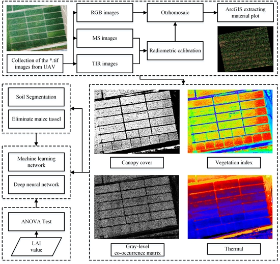
Multi-source remote sensing data fusion processing framework.
Leaf Area Index (LAI) is an important part of crop phenotypic parameters for evaluating crop growth and yield estimation, which is beneficial to high-throughput phenotypic analysis and precision agriculture of maize. Multimodal data is helpful to improve the accuracy of estimating maize canopy LAI and provide implications for other key phenotypic traits of maize. In addition, it is significant to understand the effects of maize heading and soil background on the estimation model of LAI.
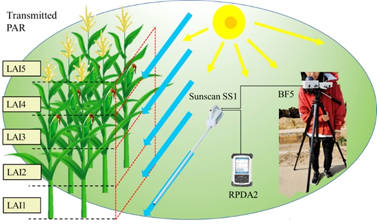
Field observation of maize LAI by Sunscan canopy analyzer
LAI data were collected by sunscan canopy analyzer and were used as the real measured value on the ground. The vertical distribution data of LAI in five horizontal planes were collected under different height of maize canopy. RGB, MS and TIR images were collected by the unmanned aerial vehicle (UAV) and constructed the multimodal data sets. Partial least square regression (PLSR), support vector machine regression (SVR) and random forest regression (RFR) methods were used to combine these parameters and estimate LAI of maize. In addition, a three-layer multilayer perceptron model was established as deep learning method to estimate the leaf area index of maize. Compared with near infrared band and red edge band, the vegetation index constructed in visible band had the best correlation with LAI. The characteristics of gray level co-occurrence matrix obtained from thermal infrared band also showed the potential to evaluate maize canopy LAI.
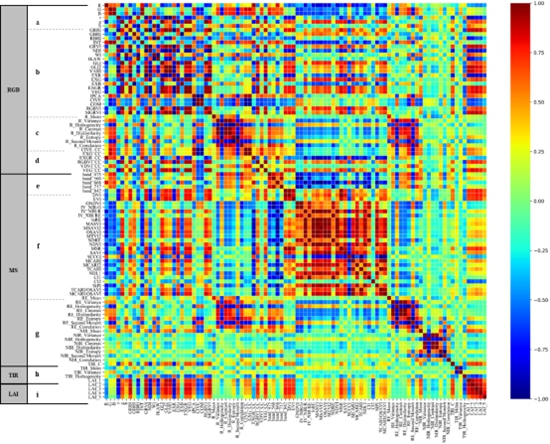
Correlation coefficient between image features and vertical distribution of maize LAI
The thermal information of maize canopy obtained in thermal infrared images were closely related to LAI which means that the thermal infrared sensors commonly used in vegetation evapotranspiration models are also very effective is estimating LAI.
Liu Shuaibing (School of Remote Sensing Information Engineering, Wuhan University) is the first author of the article. Jin Xiuliang (researcher of ICS-CAAS) is the correspondent author of the article. The research is supported by the National Key Research and Development Program, the National Natural Science Foundation, the National Key Basic Research and Development Program and the Scientific and Technological Innovation Project of the Chinese Academy of Agricultural Sciences.
The original link of the paper: https://academic.oup.com/plphys/advance-article-abstract/doi/10.1093/plphys/kiab322/6321903?redirectedFrom=fulltext
By Jin Xiuliang (jinxiuliang@caas.cn)
-
 Apr 18, 2024Opening Ceremony of the Training Workshop on Wheat Head Scab Resistance Breeding and Pest Control in Africa Held in CAAS
 -
 Apr 03, 2024IPPCAAS Co-organized the Training Workshop on Management and Application of Biopesticides in Nepal
 -
 Mar 28, 2024Delegation from the School of Agriculture and Food Science of University College Dublin, Ireland Visit to IAS, CAAS
 -
 Mar 25, 2024Director of World Food Prize Foundation visited GSCAAS
 -
 Mar 20, 2024Institute of Crop Sciences (ICS) and Syngenta Group Global Seeds Advance Collaborative Research in the Seed Industry